Conservation GIS & Remote Sensing
Land-cover analysis, deforestation interpretation and publication-ready maps for NGOs, research teams and environmental organisations.
About
I trained as a forest engineer at the Universidade Federal do Acre, and my undergraduate research traced thirty-seven years of land-use change inside the Chico Mendes Extractive Reserve, using MapBiomas data and Google Earth Engine to ask how policy, settlement and illegal deforestation reshape the western Amazon.
Since 2021 I've worked across three worlds: as a research assistant at Cornell University on aspirational well-being for Amazonian youth; as a technical assistant at CPI-Acre, supporting indigenous territorial monitoring on the Nawa, Nukini and Cabeceira do Rio Acre lands; and as the founder of ACS Consultorias, which has reached more than 400 people through geotechnology training and environmental regularization in the Amazon.
I design websites for the same kinds of clients, clean, calm, content-first sites for consultancies and conservation projects who deserve better than a template.
Through ACS Consultorias, I have delivered geotechnology training and environmental regularisation support to more than 400 people across the Amazon. My research mapped 37 years of land-cover change in the Chico Mendes Extractive Reserve using MapBiomas and Google Earth Engine.
View capability statement →What I do
From satellite imagery and field data to publication-ready maps and interactive web tools, for organisations working at the intersection of land, forest, compliance and community.
Land-cover analysis, deforestation interpretation and publication-ready maps for NGOs, research teams and environmental organisations.
CAR/PRA-style spatial documentation, field-data organisation and map deliverables for rural producers, consultancies and legal/agronomic partners.
Public-facing maps, project portals and territorial intelligence tools for organisations that need their data to move people.
QGIS, MapBiomas, Google Earth Engine and field data workflows for teams and organisations needing in-house GIS capacity.
Cartography & Spatial Analysis
A small portfolio of recent work, interactive web maps and printed atlases.
Two interactive layers: the territories I have worked in, and the protected areas (RESEX, indigenous lands, Flonas, RDS, ESEC and state units) I have supported. Tap a marker for context.
Territories of work experience
Protected areas worked with (categories)
Parcels, zoning overlays and surrounding amenities for a Turkish land-investment firm, rendered to feel less like a GIS export and more like a brochure.
Open the live mapPrint · Atlas, UFAC, 2024
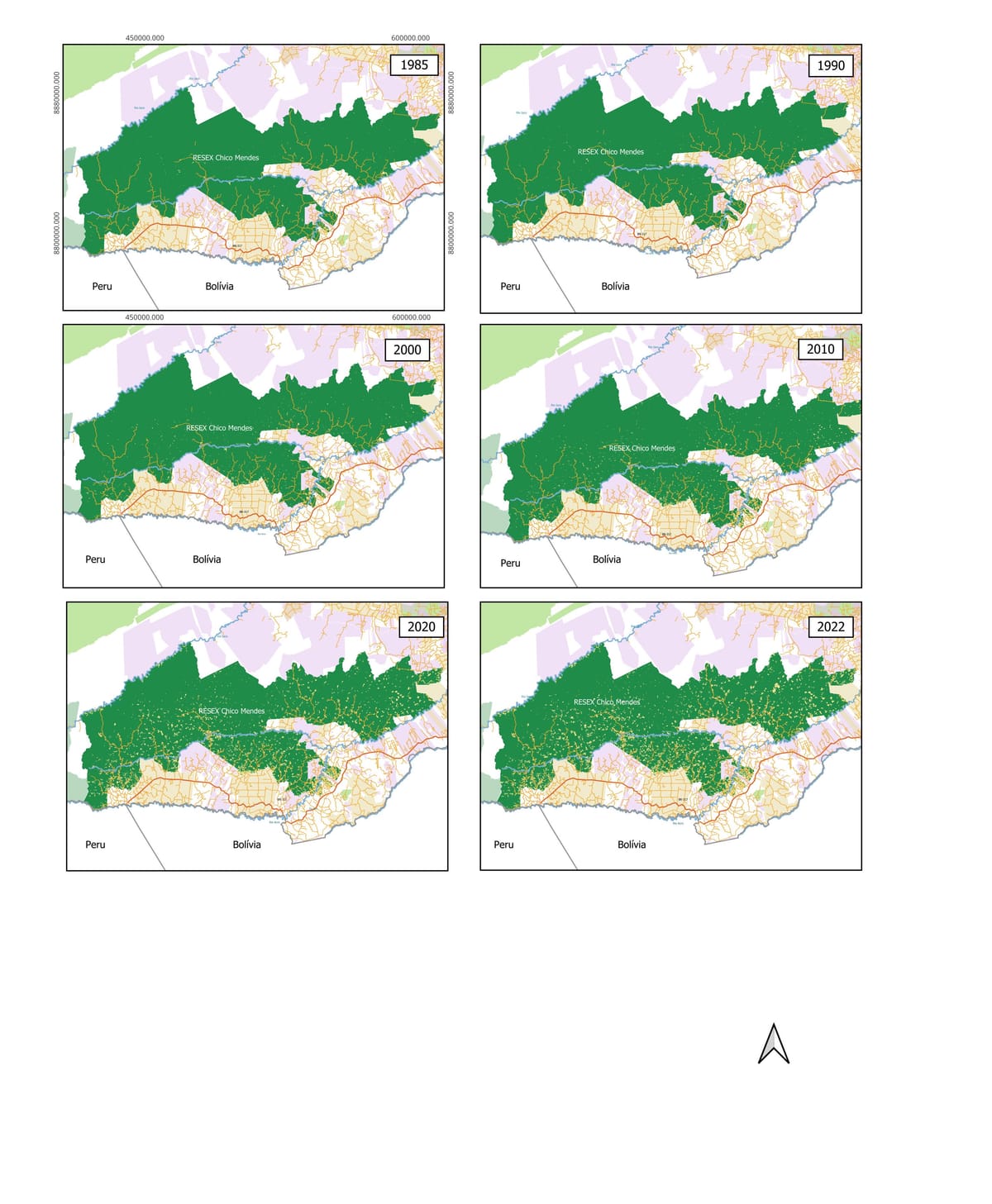
Thirty-seven years of land cover, read frame by frame. Scroll through the captions on the right; the atlas on the left follows you.
1985 Setting the scene
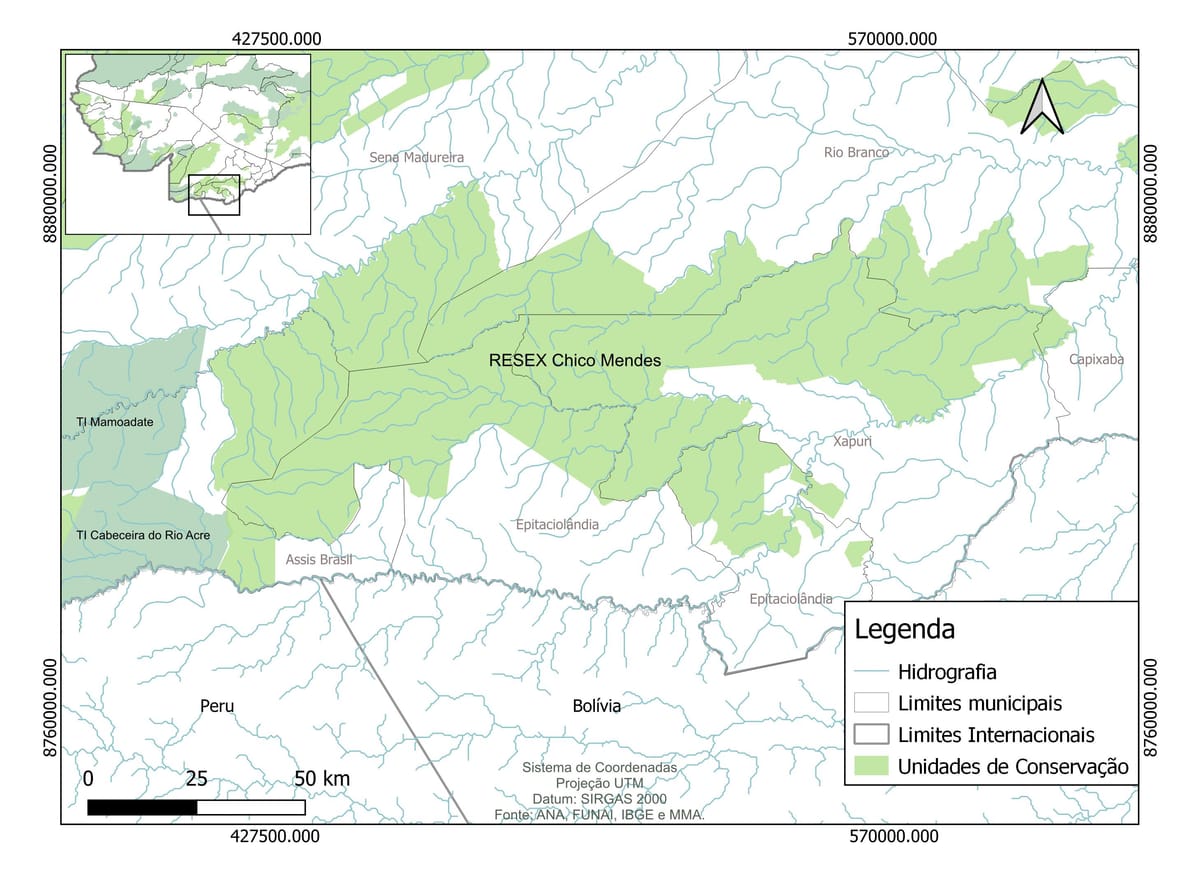
Before reading land-cover patterns, the regional frame: the Chico Mendes RESEX outlined against the rivers of the western Amazon, the Mamoadate and Cabeceira do Rio Acre indigenous lands at its western edge, and Xapuri and Assis Brasil at the southern margin.
1985 Baseline
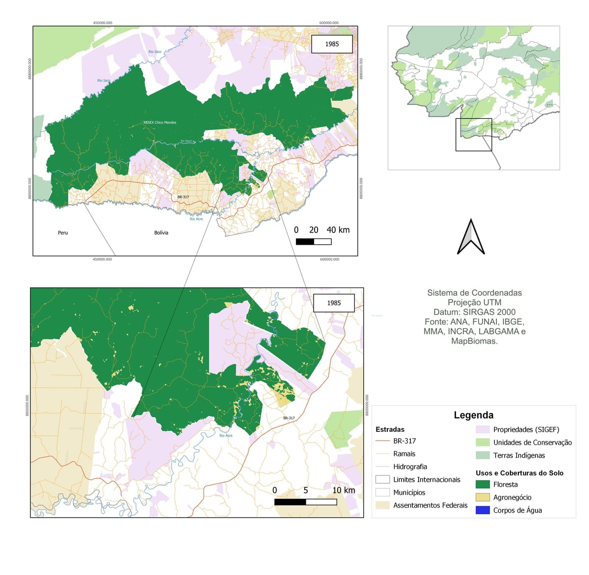
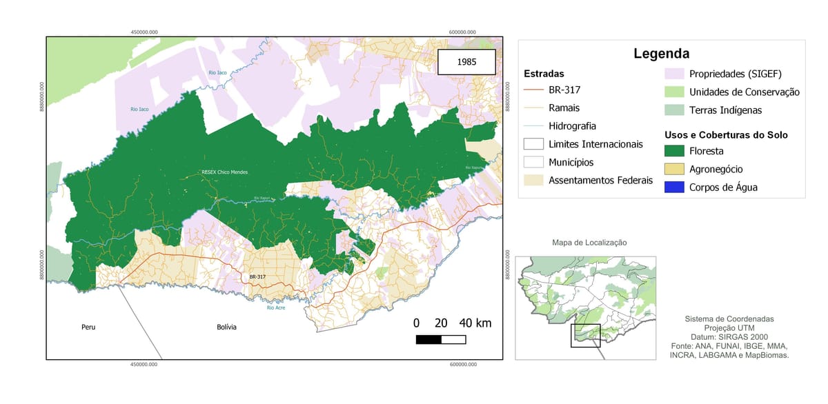
First MapBiomas-derived land-cover plate for 1985. Deep forest (Floresta) fills the reserve interior; a fishbone of federal settlements and SIGEF properties clusters along the BR-317 corridor to the south, with agribusiness (Agronegócio) below it.
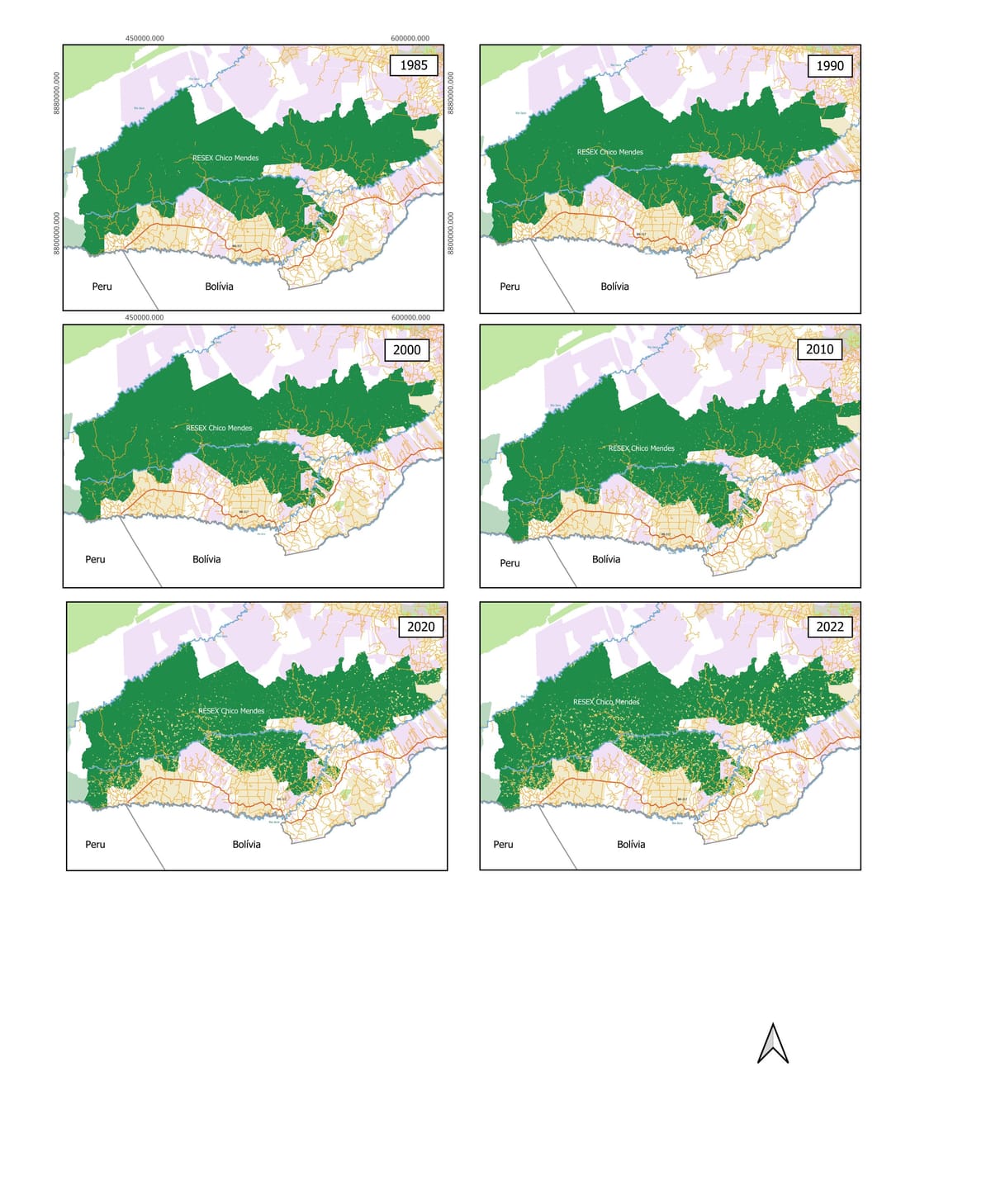
1985 → 2022 The temporal arc
Six panels from MapBiomas Collection 8: 1985, 1990, 2000, 2010, 2020, 2022. The reserve's interior holds, but the agricultural margin (yellow) widens visibly each decade along the BR-317 corridor.
1985 Reserve in detail
Same year, alternate framing. The eastern flank of the RESEX against the dense mosaic of federal settlements and SIGEF properties south of the BR-317.
1985 A 1:10 km zoom
Regional context plus a fine-scale inset. The ramais (orange) opened by colonists branch off the BR-317 into federal settlement and SIGEF properties. Forest still dominates inside the reserve.
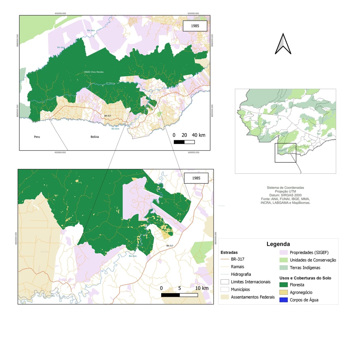
1985 Finest scale
Closest cut of the 1985 data. The linear pattern of cleared ramais and small clearings just outside the reserve sets the trajectory of land-use change that the temporal arc then plays out.
MapBiomas-derived land use and land cover plate for the Chico Mendes Extractive Reserve in 1985: forest, agribusiness, surrounding indigenous lands and conservation units. From the UFAC undergraduate monograph (Venâncio, 2024). Sources: MapBiomas Coll. 8, ANA, FUNAI, IBGE, MMA, INCRA. SIRGAS 2000 / UTM.
Design for the web
Lead designer & developer · 2025
Editorial-style site for a London-based engineering consultancy.
Lead designer & developer · 2025
A bilingual property-investment site with embedded interactive map.
Collaborator · 2024
Contributing designer on a German solar-energy company's bilingual presence.
Environmental regularisation infrastructure
MVP · Work in progress
Envreg is a service for environmental regularization in rural Brazil, built on the same fieldwork, GIS pipelines and community engagement my team has used since 2021. The platform is in active development, and I'm currently inviting partners: regional agronomists, environmental lawyers, fintech operators and investors who care about the Amazon.
Envreg combines GIS evidence pipelines, legal/agronomic partner workflows and producer-facing documentation, built for Acre, Rondônia and southern Amazonas, where the regularisation gap is largest.
My B2B and B2C consultancy supporting rural producers, indigenous communities and conservation projects across the Amazon since 2021.
acsconsultorias.com.brOrganisations & Partnerships
Organisations I have worked with directly, indirectly, as a partner, consultant, employee or volunteer, in Brazil and abroad.
ICMBio Integrated Management Nuclei (NGIs) I have worked alongside
Curriculum Vitae
From education to current consulting work, scroll down to follow the path.
Jul 2015 – May 2024
Universidade Federal do Acre (UFAC)
Monograph: Tendência na Evolução Temporal do Uso e Cobertura da Terra na Reserva Extrativista Chico Mendes — Um Estudo com Base em Dados do MapBiomas (1985–2022).
May 2021 – present
ACS Consultorias
Environmental regularisation and geotechnology training across the Amazon, 400+ people reached.
Apr 2023 – Oct 2025
Cornell University (USA), Dr. Renata Leitão
Aspirational well-being for Amazonian youth.
Apr 2021 – Jul 2023
CPI-Acre (Comissão Pró-Índio do Acre)
Indigenous territorial monitoring, Nawa, Nukini and Cabeceira do Rio Acre lands.
Sep 2019 – Apr 2021
INCRA (Instituto Nacional de Colonização e Reforma Agrária)
Land-reform and conservation analysis.
Jul – Aug 2025
LHA Londres (United Kingdom)
Six-month period in England, international exchange and language immersion.
Aug 2017 – Feb 2018
Comitê Chico Mendes
Conservation and memory work around the legacy of Chico Mendes.

Contact
Get in touch to discuss a project or consultancy.
Project enquiries, partnership ideas, or just to say hello. I read every message and reply within two working days.
Or use one of these structured enquiry forms.
I read every message and reply within two working days.